GPS coordinates for the Beach Club:
Longitude 66.0 W, Latitude 10.4° N.
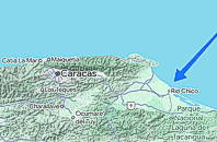
An island-like setting, Isla de Oro is a famous reference that point that everyone in the Rio Chico area is familiar with, in case you need to ask for directions.
To get there, you will be going to the town of Rio Chico ("Little River") on the Caribbean coast a bit east of Puerto Encantado
and Higuerote.
The trip is 79 miles (128 km) from Caracas on freeway most of the way and can be done in about an hour.
Leave Caracas on the eastbound freeway out of town past the Makro
hypermarket. Pass Guarenas, then Guatire, going east until Caucagua, then continue on the freeway, veering left towards "Higuerote".
Before Higuerote, you reach Tacarigua. Veer right at sign saying "Rio Chico".
Going through Tacarigua, you then enter a small tropical forest known locally as the "Tunel Vegetal" followed by Mamporal.
You are now nearing San Jose de Rio Chico.
The town is the chocolate capital of the country, showcasing this with a huge monument of a 17 ft tall cocoa bean
right at the entrance to town. But if you see that, you have already
driven too far ... because the turn-off to the Beach Club is a
mile BEFORE this.
For privacy reasons, the turnoff has no signpost, but it is the only
crossroads for miles. You can recognize it by a police guardhouse
on the right hand side -- the first of several "rings" of security,
and a holdover from the days when the Beach Club was the personal playground
of the country's President.
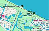 Turn left here.
 Then go straight four miles, until you reach
the Caribbean Ocean.
Then go straight four miles, until you reach
the Caribbean Ocean.
The road is a dead-end road, made just for us.
It ends at the
gated entrance to the Isla de Oro Beach Club, right on the beach.
Once here, you're home.
Identify yourself at the main gate. Then enter the Club ... and enjoy.